Know the area before you commit
Everything about an area — schools, crime, transport, flood risk, prices and more — for any UK postcode, in one report built on official data.
- Tailored to your market
- Built on official UK data
- No obligation
- official UK data sources
- 10+official UK data sources
- UK postcode or address
- AnyUK postcode or address
- to a full report
- Secondsto a full report
- PDFs for your clients
- White-labelPDFs for your clients
Who it's for
For every big property decision
Whether you're buying, renting, investing or advising clients, AreaSense gives you the full picture of an area before you commit.
Homebuyers
Make offers with confidence. Evaluate school ratings, local safety, flood risks and recent sales data before making a commitment.
Renters
Know the neighbourhood first. Check commute times, broadband speeds, local amenities and safety metrics before signing a lease.
Investors
Discover high-demand postcodes. Compare local growth trends, rental demand and market indicators to target top-performing areas.
Estate agents
Win more listings. Generate white-label area reports and side-by-side location comparisons to share directly with clients.
What's in a report
Everything about an area, in one place
Every category is pulled from an official UK source and turned into plain English — no ten browser tabs, no jargon.
Schools & Ofsted
Every nearby school with its Ofsted rating and full inspection history.
Ofsted · Dept for Education
Crime & safety
Area crime level, a breakdown by category and how it compares nationally.
Police.uk
Transport & signal
Connections, live timetables, accessibility and the best mobile signal.
Timetables · Ofcom
Health & NHS
Nearest GP, dentist, pharmacy and hospital, plus how well the area is served.
NHS
Flood & planning
Flood-risk signals, nearby planning activity, conservation areas and Green Belt.
Environment Agency · MHCLG
EPC & energy
Current and potential energy rating, with improvement ideas and likely savings.
EPC Register
Demographics
Household make-up, tenure and deprivation, mapped against the UK average.
ONS
Prices & rental
Sold-price comparables, price history and rental-demand signals for the area.
HM Land Registry
Plus air quality, road noise, broadband coverage, EV charging, local amenities, radon & ground stability and Companies House activity.
See it in action
Clear visual reports, easy to digest
See how AreaSense turns raw postcode data into actionable reports.
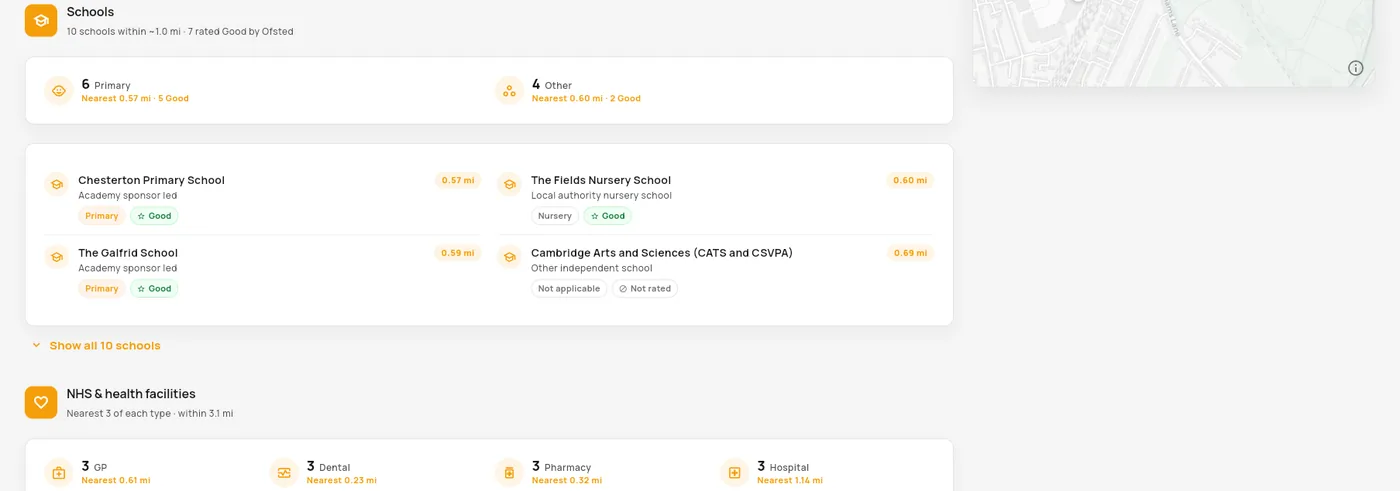
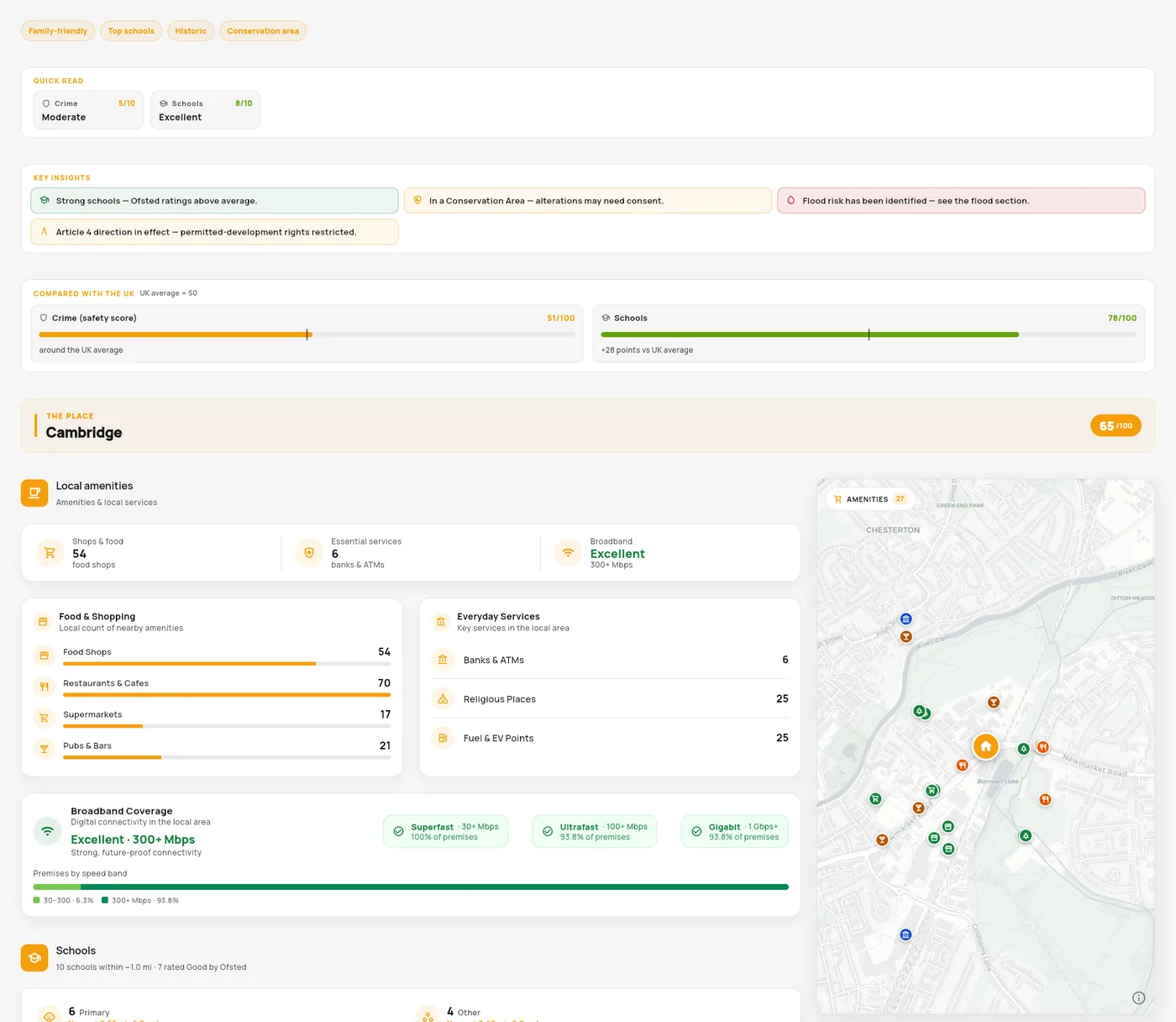
One scrollable report
Get an executive summary, category scores, local amenities and an interactive map within a unified report.
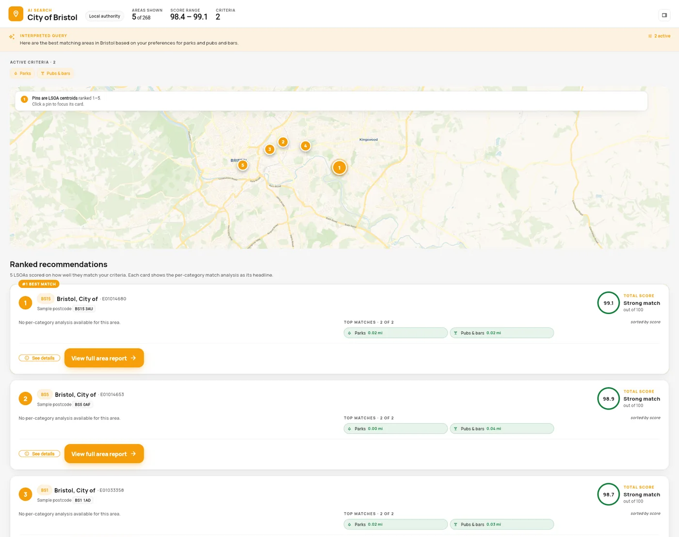
Rank areas by what matters
Tell AreaSense what you need in an area and get a tailored list of top-matching postcodes.
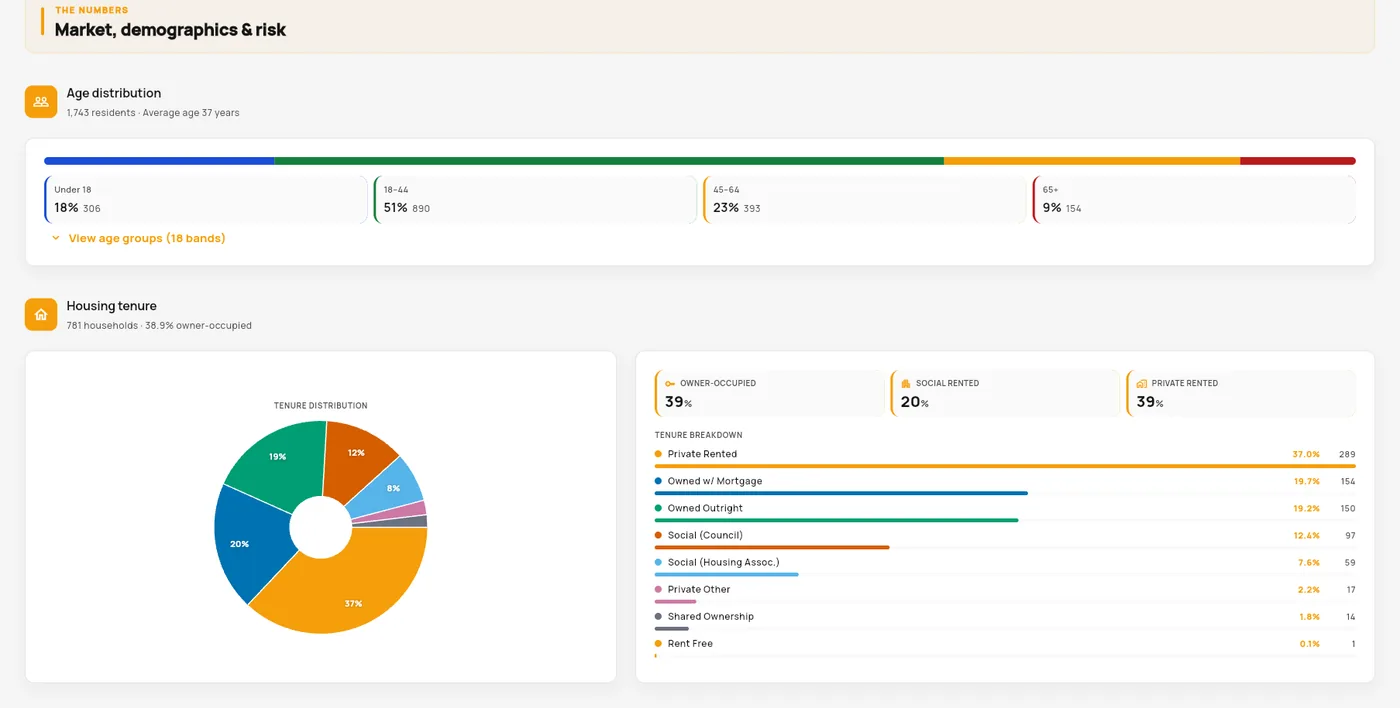
Charts, not spreadsheets
Demographics, tenure and the local market turned into clear charts you can actually read.
How it works
From postcode to full report in three steps
- 01
Search your location or preferences
Enter a postcode, full address or describe the specific qualities you want in an area.
- 02
Review instant area scoring
Access a detailed report instantly, featuring key category metrics and a clear executive summary.
- 03
Decide with confidence
Evaluate locations side by side, save shortlists and export custom PDF reports to share with clients or partners.
Built on official UK data
Every figure traces back to a source
We source data directly from official UK public records, standardising and timestamping every metric so you always know its exact origin and freshness.
HM Land Registry
Sold prices & tenure
Ofsted
School ratings
Police.uk
Crime
Environment Agency
Flood & environment
NHS
Healthcare
ONS
Demographics & deprivation
EPC Register
Energy efficiency
Ofcom
Broadband & signal
Food Standards Agency
Food & hygiene
Companies House
Local business activity
Why AreaSense
Made for a confident decision
No hype, no guesswork — just the facts that matter, laid out clearly.
One clear report
Everything about an area on a single scrollable page — no ten browser tabs.
Plain-English AI summary
The gist of the area in a sentence or two, before you dig into the detail.
Built on official data
Land Registry, Ofsted, Police.uk, the Environment Agency and more — no guesswork.
Compare areas side by side
Put two areas head-to-head and get an AI verdict on which fits you best.
Exportable, brandable PDF
Download a clean report to keep or share — white-labelled for agencies.
Free to try
Start with a free basic report — no card, no sign-up to get going.
FAQ
Questions, answered
Where does the data come from?
Every report is compiled from official, public UK sources — HM Land Registry, Ofsted, Police.uk, the Environment Agency, NHS, ONS, the EPC Register, Ofcom, the Food Standards Agency and Companies House, among others. Each section shows what it's based on.
How accurate and up to date is it?
AreaSense reflects the underlying official datasets and shows when the data was last updated. Public data can lag or contain gaps, so we date-stamp it and present it plainly rather than smoothing over the source.
How much does AreaSense cost?
Pricing is tailored to how you'll use AreaSense — from individual research to white-label reporting for agencies — and is being finalised during beta. Book a demo and we'll walk you through the plan that fits.
Which areas are covered?
AreaSense covers postcodes and addresses across the UK. Coverage of some datasets varies between England, Wales, Scotland and Northern Ireland, and the report notes where a source is limited.
How is the area score worked out?
Scores summarise official metrics for a section (for example crime rates or school ratings) and are shown alongside the numbers they come from, plus a comparison to the UK average — so you can always see what sits behind a score.
Is this financial or property advice?
No. AreaSense is information to help you decide with confidence. Reports are for general information only and are not legal, financial, planning or surveying advice — always do your own due diligence before you commit.
How do I get started?
Book a demo and we'll walk you through AreaSense on your own patch, then get you set up with access that fits how you work — or email contact@areasense.co.uk.
Can estate agents brand the reports?
Yes. The Agency plan lets you white-label exported PDF reports with your own logo and details, then compare areas for clients — handy for winning and progressing instructions.
Ready to see AreaSense on your patch?
Book a tailored walkthrough — area reports, side-by-side comparison and white-label PDFs for your team.